Further Monitoring on the Effects of Ploughing on Archaeological Remains
Introduction
This paper presents the results of further experiments to monitor the effects of ploughing at Ladybridge Farm. It follows an original experiment undertaken between March and October 2005 in the southern portion of the site which clearly demonstrated that the normal agricultural regime was having a detrimental effect on in situ early prehistoric archaeological deposits. The results of that experiment have been published and can be accessed at www.archaeologicalplanningconsultancy/papers/001_plough.html.
In October 2005 additional archaeological trenching was undertaken on Ladybridge Farm as part of a planning application (Timms & Dickson, 2005). This work defined an area of archaeological potential (see figure 1, below) in the southern and western parts of the site. The area of archaeological potential was characterized by a promontory of marginally higher ground on and above the 41.5m contour which would have been dry throughout prehistory. The lower lying area to the north would have comprised marsh or bog and been unsuitable for occupation, settlement or burial until the land was drained in the post medieval period.
After the archaeological trenching was completed in November 2005 the farmer resumed his normal agricultural regime. At that time the fields along the southern edge of Ladybridge Farm had already been planted with a crop of barley which is not due to be harvested until August 2006. The fields across the central section of the farm had been used to grow a root crop for animal fodder. By February 2006 the crop had been consumed and the fields were again ready to be ploughed and seeded.
As the area of archaeological potential lay within the western part of these fields the opportunity was taken to establish a further two monitoring pits. These were located to establish what impact, if any, the current ploughing regime was having in an area which potentially contained early prehistoric archaeological features. The results are described below.
Methodology
Two plough monitoring pits were established on Ladybridge Farm on 3rd March 2006. The location of the pits is shown in Figure 1, below. The pits were positioned within the area of archaeological potential, approximately 30 metres from the western boundary and 100 metres apart.
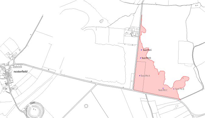
Figure 1. Test Pit Locations (size exaggerated). Area of potential shown in red, previous test pits also illustrated.
Each pit measured 1.50 metres by 1.50 metres and was excavated by hand. A one metre square sondage was cut into the subsoil which was subsequently filled with marker artefacts. These comprised two layers of glass chippings each 20mm thick. The uppermost layer was white, the lower level green. Following the careful placement of the marker artefacts each pit was backfilled and compacted by hand. Each pit was located using a total station theodolite and the soil profiles recorded.
 |
 |
 |
| Test Pit E after excavation of sondage | Green beads added | White beads added |
The field was ploughed in early April 2006 as part of the normal cultivation sequence for Ladybridge Farm. The depth of ploughing was kept constant, with the plough being supported by a hydraulic arm at the back of the tractor and a guide wheel at the back of the plough.
Following ploughing the location of each monitoring pit was re-established. An area of 10 metres square centred on each of the pit locations was the subject of total coverage fieldwalking to identify any displaced marker material. Where observed the location of the marker material was recorded using a total station theodolite (TST) to survey a series of target points surrounding the scatter. The material encompassed within these target points was then photographed, and each photograph rectified according to the known survey targets. Once rectified the images were georeferenced and the location of each visible marker artefact was digitised in CAD software. By recording the spread in this manner the marker artefacts could be left in position, and it will therefore be possible to monitor their subsequent movement caused by continued agricultural activity.
 |
 |
| Part of surface scatter surrounded by survey targets | The same image rectified |
Results
Test Pit D showed no indication of having been disturbed by ploughing. No marker artefacts were visible on the surface of the ploughsoil.
At the location of Test Pit E, however, a significant number of marker artefacts were visible at the surface. In total 984 marker artefacts were recorded on the ploughsoil surface. Of these 288 were from the lower layer (green) while 696 were white. The glass chippings were dispersed in a linear spread extending approximately 13.50 metres in length and varying between 1.60 and 2.10 metres in width. A flint scraper was also recovered and recorded on the surface of the ploughsoil at the eastern end of the scatter.
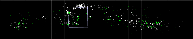
Distribution of marker artefacts over Test Pit E (grid at metre intervals)
Discussion
The resulting spread of material from Test Pit E clearly demonstrated that subsoil deposits in this area of the site are being impacted by the current regime of ploughing. The disturbance of green beads indicated that the plough had cut at least 20mm into the subsoil. The distribution of marker artefacts suggests that the northern half of the test pit had been struck as the ploughing moved from west to east. The southern half of the pit was struck on the plough's return leg, moving the artefacts in the opposite direction. This has resulted in a linear spread of material measuring 13.50 metres, derived from a single feature.
The displacement of marker artefacts by up to 7.50 metres from their point of origin raises questions over the spatial integrity of surface scatters at Ladybridge Farm, and for that matter the Thornborough area. With such a large movement of material evident from a single ploughing, successive events could have a substantial effect on the distribution of artefacts on the site by dispersing them over a large area in a relatively short time. This effect would be quickly increased if ploughing was undertaken along the same axis year on year. The distribution of surface material is further confused if we consider that movement of material may be happening at different rates on the same site and in different directions if the farming regime changes. Other factors such as topography and artefact size may also have an effect. In this context the value and potential of lithic distributions in the area is extremely limited as anything other than a general indicator of human activity in the vicinity.
At Test Pit D there was no evidence for the disturbance of the marker artefacts by ploughing. This appears to be a result of the deeper cover of ploughsoil in this area. When both monitoring pits were excavated their soil profiles were recorded. In Test Pit D the natural subsoil was covered by 0.31 to 0.37 metres of ploughsoil. In Test Pit E the depth of the ploughsoil varied between 0.21 and 0.27 metres.
The difference in the ploughsoil depths between the two Test Pits, therefore, appears to be the main variable responsible for determining the impact of the ploughing. Further evidence for shallower soil cover was visible elsewhere in the fields. Numerous patches of orange yellow subsoil were observed on the surface over the northern two thirds of the field following the ploughing, whilst only occasional patches were visible in the area to the south.
The reasons for this variation in soil depth over the site is as yet unclear but may be related to topography, differences in the underlying subsoil, or even past land use. What is evident from the observed distribution of re-deposited subsoil on the surface of the field is that the impact of ploughing on subsoil deposits is widespread and may effect up to 60% of the area.
Conclusions
The experiment has shown that subsoil deposits are being compromised by the current normal agricultural regime in an area of archaeological potential on Ladybridge Farm. The differential impact of ploughing appears to be related to the depth of soil cover across the field. The experiment has demonstrated that in areas where the ploughsoil cover is around 0.25 metres over 20 millimetres of subsoil deposits have been truncated by a single episode of ploughing. It is clear that if archaeological deposits are present within this area of Ladybridge Farm then they are not in a static state of preservation but are continuing to be eroded and lost without record.
In light of these results there is an overriding need to reevaluate the integrity and interpretation of finds scatters across the wider area. More research and monitoring is required to establish the processes which may lead to or distort artefact distributions and increase our understanding of the archaeology of the area.
References
Dickson, A., Hopkinson, G. & Timms, S. 2005. 'The Effects of Agricultural Practices on Archaeological Remains'
Timms, S. & Dickson, A. 2005. 'Ladybridge Farm, Nosterfield. Report on an Archaeological Investigation'
archaeological planning consultancy > thornborough > further monitoring on the effects of ploughing on archaeological remains
Internet highlights
- UK Casinos Not On Gamstop
- Betting Sites Not On Gamstop
- Gambling Sites Not On Gamstop
- Non Gamstop Casino
- Best Non Gamstop Casinos
- Sites Not On Gamstop
- Casinos Not On Gamstop
- Best UK Casinos Not On Gamstop
- Non Gamstop Casinos
- Non Gamstop Casinos
- UK Sports Betting Sites
- UK Slot Sites
- Non Gamstop Casino
- Casinos Not On Gamstop
- Non Gamstop Casinos
- Non Gamstop Casinos
- Gambling Sites Not On Gamstop
- Casino Not On Gamstop
- UK Casinos Not On Gamstop
- UK Online Casinos Not On Gamstop
- Non Gamstop Casinos