Printed from the APC web site: navigation and non-essential images removed.
Please view on-line for full content (URL at end of document).
Report Date: 17th February 1995.
Prepared by: AOC Archaeology Ltd, The Schoolhouse, 4 Lochend Road, Leith,
Edinburgh, EH6 8BR
On behalf of: Tilcon Ltd
The assessment was carried out for Tilcon Ltd. in advance of the extension of their gravel quarry at Nosterfield. At this stage two areas were to be investigated; a corridor to the west of the old quarry for the haul road leading north to an extraction area of 4.7 hectares at the Flasks, and a rectangular area to the east of the old quarry pit measuring about 400 m by 150 m.
The fieldwork was carried out from the 23rd to the 29th of January 1995.
A detailed survey of the archaeology in the area around the quarry has been carried out by Mike Griffiths (Griffiths 1991, 1992). The main archaeological features in the area are three late Neolithic or early Bronze Age henges to the south of the quarry. This area to the south also contained several barrows, the nearest was located about 300m south of the proposed haul road.
The assessment was carried out by excavating eleven trial trenches, spanning the proposed areas of development (Figure 1). All trenches were 100m long and 2m wide, the only exception being trench 2 which was 200 m long. The topsoil was stripped by machine and features visible against the subsoil were cleaned up and investigated further.
The trenches were set out according to the layout provided by Mike Griffiths. At the end of the fieldwork the positions of the trenches and features within them were located within the National Grid using the position of boundary junctions.
The area by the Flasks (Phase 5b) covers 4.7 hectares. The Flasks is an area of level raised ground, 2 to 3 m high, and about 150 m in diameter. The proposed extraction zone covers the western parts of this area. Three trenches were laid out here radiating roughly from the centre of the platform, running down on to the lower ground on the south and west side of the Flasks.
The trench was aligned approximately east to west, on the west side of the Flasks. It contained three features, all probably modem. At the west end was a small sub-rectangular pit (Cut 102) 0.7 by 0.4 m and 0.08 m deep. Two meters further east was a rectilinear ditch (Cut 104), aligned northeast to southwest, about 2 m long, 0.5 m wide and 0.15 m deep. The base was stepped as if it had been excavated by spade. A modern iron nail was found in the fill, indicating that it is a recent feature.
About 50 m from the west end, a linear feature (Cut 106) aligned northwest to southeast, 0.6 m wide and 0.2 m deep, crossed the trial trench. Remains of tree roots were preserved in the fill. The feature can be identified as an old hedge row, as the current 1:2500 map shows a boundary in this position on the same alignment as the feature. The boundary is mapped on the first edition Ordnance Survey map from 1853, but is no longer visible on the surface, having been removed since the latest map revision.
The trench was aligned north-east to south-west, running from the middle of the Flasks down onto the lower area to the south-west. To avoid cuffing through Flask Lane, it was divided into two parts, 30 m to the south of the lane and 160 m to the north.
The trench contained two features. The boundary line seen in Trench 1 was also visible in this trench, but not investigated any further. At the north-east end of the trench was a rounded pit (Cut 202), 1.3 m to 1.1 m in diameter and 0.45 m deep. The fill contained a modern glazed pot-sherd, iron nails and fragment of a roofing slate. The first edition Ordnance Survey map from 1853 shows a T-junction between two boundaries at this point. None of these boundaries are visible on the present ground surface. The feature is likely to have been created when these boundaries were removed.
The subsoil in the southwest end of the trench consisted of tufa (marl). The deposits were seen in the lower area running up to the base of the slope up to the Flasks (Figure 1).
The trench ran from the north side of Flask Lane across peaty ground up onto the Flasks. No features were visible in this trench. As in Trench 2 tufa was seen on the lower ground at the south end of Trench 3 (Figure 1).
This area is a narrow corridor running north from the main road up to the Flasks. It is about 400m long and covers 1.5 hectares. At the north end it runs across a wet peaty area rising up over a low ridge to the south. Three 100m long trenches were laid out in a row along middle of the corridor.
Trench 4 ran south from the south side of Flask Lane. The topsoil was peat 0.4 to 0.5m deep. The only man-made feature seen was a modem field drain at the south end of the trench.
As in Trenches 2 and 3, part of the subsoil consisted of tufa (Figure 1). In Trench 4 the tufa deposits were 40m wide starting 18m from the north end of the trench. A test hole excavated in the middle revealed that the deposits were over 1.5 m deep. A small test pit excavated at the southern edge of the deposits showed that the deposits were interleaved with peat.
Trench 5 was aligned north to south about 30m south of Trench 4. The topsoil was gravelly at the south end and peaty down slope at the north end. No archaeological features were seen in the trench.
Trench 6 was placed at the south end of the haul road area. It ran from the top of a low rise downhill towards the north.
The trench contained two features. At the north end was a small sub-rectangular pit (Cut 605), 0.5 by 0.4 m (figure below). It was 0.12 m deep and filled with dark brown/black silt containing charcoal and rounded stones 0.02 to 0.15 m across. The cut was steep-sided with a sharp break of slope to a flat base on three sides and a more gradual slope on the north side.
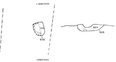
Feature 605 plan & section
About 65 m to the north was another sub-rectangular pit (Cut 603) measuring 0.6 by 0.5m, and 0.14m deep (figure below). The fill and shape of this pit was very similar to that of cut 605 with a flat base and steep sides, except to the north which was a more gradual slope.
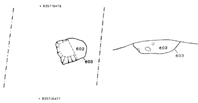
Feature 603 plan & section
The two features are very similar both in form and content. They are therefore likely to be roughly contemporary and of the same origin.
This area covers 6.1 hectares. It is 130 to 150 m wide and 400 m long, aligned north to south. Apart from the slopes down to the old quarry to the west, the ground is fairly level. Five 100m long trenches were laid out in zigzag pattern from north to south along the area.
Trench 7 was at the north end of the area and was aligned northeast to southwest. The trench contained one feature (Cut 702), a circular pit 0.95m in diameter and 0.33m deep, about 40m from the south end of the trench (Figure 2). The pit was filled with light grey brown sandy silt with some small rounded stones (0.03 m) and a few charcoal flecks. It contained no inclusions which could indicate the nature or antiquity of this feature.
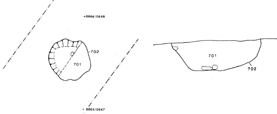
Feature 702 plan & section
Trench 8 ran southeast from the southwest end of Trench 7. It contained one ill-defined feature which proved to be natural, probably root disturbance.
Trench 9 ran southwest from the southeast end of Trench 8. It contained three areas of light grey gravel. The soil textures of these areas were the same as that of the surrounding brown gravel, and they contained no inclusions which could indicate that they were man-made. The features are therefore likely to be natural - the colour difference could have been caused by soil processes.
Trench 10 ran southeast from the southwest end of Trench 9. The trench contained one feature (Cut 1002), a possible ditch terminating within the trench. The feature continued under the section on the south side, and was exposed within the trench for 1.2 m (figure below). The north end was rounded. It was 0.77 m wide east to west, 0.31 m deep and filled with grey brown sandy silt with numerous stones up to 0.15 m across. The stony nature of the fill suggests that it contains some subsoil, which may imply that the fill was created by the slow process of erosion of the ditch sides. The fill contained no inclusions which could indicate the date of the feature.
Feature 1002 plan & section
Trench 11 was at the south end of the area. It was aligned north-east to south-west, and contained four features.
About 12m from the north end of the trench was a cut feature (Cut 1103) partly exposed within the trench (figure below). It was 1m wide along the west edge of the trench and terminated 0.9m from the trench edge. The cut had steep sides, was up to 0.7m deep and was filled with gravelly silty sand. The fill contained no inclusions. In the base of the cut were two depressions, 0.10 to 0.15m deep, which could be post-holes. If this interpretation is correct, the feature may be the east end of a palisade trench.
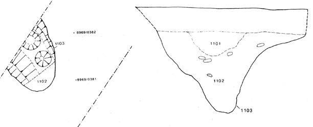
Feature 1103 plan & section
About 10m to the southwest was an area of mixed brown gravel mottled with paler orange silt. Although the feature (1105) was visible in the east-facing section, it had ill-defined edges elsewhere. It is therefore most likely to be a natural disturbance rather than a man-made cut.
Some 15m from the south end and along the west side of the trench was a straight-sided flat bottomed cut (Cut 1107), 1.7 m wide and 0.4 m deep, with well defined edges. The cut was filled with mixed dark brown gravel. Although only part of the feature was exposed within the trench, the shape of the feature suggests that it was made by a JCB bucket.
About 5m further north along the west side of the trench, was another well defined angular cut (1108). The pit was not examined any further as the fill contained sheep bones, identifying it as a pit excavated to bury one or more sheep.
Of the four features exposed in this trench, only one cut (1103) is likely to be of archaeological interest. The remaining features are likely to either natural or modern features.
Although the Flasks was believed to be an area of some archaeological potential, the three trenches in this area did not expose any medieval or prehistoric features. The features seen in Trenches 1 and 2 are all fairly modern. Two of the features (106 and 202) are clearly linked to removed boundaries mapped on the present 1:2500 map. These are also recorded on the first edition Ordnance Survey map from 1853, as part of an old field system.
The two northern trenches in the haul road area did not reveal any significant features, but the two pits discovered in Trench 6 are likely to be of archaeological interest. The fill of both pits contained carbonized material, and samples from both pits were therefore wet sieved. The fill of the pits contained charcoal and carbonized fragments of nut-shell (hazel) (Holden 1995). Amongst the retents from the wet sieving of these samples were a few small lumps of slightly burnt clay and a few small fragments of flint. The flint and the nut-shell may indicate that these pits are of Mesolithic date. The nearest Mesolithic site lies on the Flasks some 500 m to the north, where during previous fieldwork some flint implements of Mesolithic origin were discovered (Griffiths 1992).
The five trenches in the east area only revealed three features that may be of some antiquity, but none of these produced any finds to support this assumption. The two features 1103 and 1002 could be a ditch terminals. If so, their alignment and shape suggest that they are two different ditches, with feature 1103 possibly containing a palisade. If these two features indicate the presence of a prehistoric settlement in this area, one would have expected to have come across more features in the trenches, unless the focus of such a settlement lies to the north and east of the trenches.
The isolated pit 702 at the north end of the area did not yield any finds, and could be of any age.
Considering the number of prehistoric monuments to the south of the area (Griffiths 1991), it is surprising that the assessment only uncovered a few archaeological features.
Apart from the archaeological features, the tufa and peat deposits have potential palaeoenvironmental importance. They should contain dateable assemblages of mollusca, pollen, insects and macroscopic plant remains, providing a record of environmental change. In view of the presence of archaeological monuments of national importance immediately to the south, a record of local environmental change has potential value.
The assessment revealed that archaeologically the most sensitive area is the southern half of the proposed haul road. The two features in Trench 6 are widely spaced, and based on the evidence from this trench, there is not likely to be a dense concentration of features in this area. On the other hand, the presence of the pits indicates that there might be further features in this southern part of the haul road corridor. It is therefore recommended that an archaeologist is present during the stripping of the topsoil to identify any further archaeological features that might be exposed.
The low lying peaty area between Trench 6 and the Flasks is not likely to contain any archaeological features, but this area may be of some palaeoenvironmental interest. It is recommended that further work be undertaken to determine the stratigraphy of the peats and the tufa. Radiocarbon dates should be obtained to determine the time period represented by the sediments. The assemblages of mollusca, pollen, insects, plant macrofossils and any other material types should be assessed to determine their suitability for further analysis.
The trenches over the Flasks only revealed modem features. However, since previous fieldwork in the area has revealed flint artefacts, it is recommended that an archaeologist watches the stripping of topsoil in this area.
The trenches in the area to the east of the old quarry only revealed a few features that may be of archaeological interest. Again the findings do not warrant a separate archaeological excavation, but the presence of an archaeologist during the stripping of the topsoil is recommended in case archaeological features were uncovered.
Griffiths, M. 1991. 'Nosterfield North. Preliminary archaeological appraisal for Tilcon Ltd', unpublished report.
Griffiths, M. 1992. 'Nosterfield North. Archaeological assessment for Tilcon Ltd', unpublished report
Holden, T. 1995. 'The Plant Remains from Nosterfield, North Yorkshire' AOC Internal report