Printed from the APC web site: navigation and non-essential images removed.
Please view on-line for full content (URL at end of document).
Archaeological Procedures
The first step in preparing an area for gravel quarrying is stripping the topsoil or ploughsoil by machine. This also means that archaeology, that would otherwise be invisible, is revealed. 'Topsoiling' by machine is a standard archaeological technique, particularly for rural archaeological sites (see the Bestwall Quarry web site for an example). All topsoiling at the quarry is monitored by archaeologists.

Archaeologist Andrew Copp monitoring topsoiling on site
The ideal time of year for topsoiling at the quarry is either the spring or autumn because the ground is not too wet or too dry. These seasons also provide premium conditions for archaeologists because the ground is damp which makes the archaeology easier to see and easier to excavate.
Archaeological features are defined by changes in the colour and nature of soils. Archaeological features such as pits and ditches that have been backfilled with soil can be seen against the natural gravel at the quarry. Once the topsoiling has been completed, archaeological features are identified, mapped and cleaned with a trowel prior to excavation (see image to right, second down).
To understand what the purpose of a feature was and how it was used and then disused archaeologists 'half-section' them.
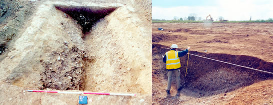
Left: ditch section photograph. Right: drawing a ditch section
Once sections have been excavated they are then photographed and drawn by hand. Drawings are then computerised and the pit section (below) shows clearly the layers of use and disuse that can build up in pits. The pit alignments are sectioned across their length and width to detect the direction that soils fall into the open pits.
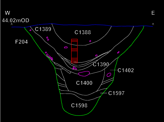
Computerised section drawing of one of the pits at Nosterfield
Some features that are found require half sectioning followed by complete excavation. This is because certain feature types promise to provide more information than a half section. Human burials and cremations, kilns, wells and buildings are among the features which are excavated completely by routine. All human burials are removed under a burial licence and guidelines on best practice provided by the Home Office.
After complete excavation, a photograph is taken of the original shape of the feature and a plan of the feature is drawn and surveyed using a total station theodolite. This allows a plan to be drawn with 3D information which is accurate to within a few millimetres.
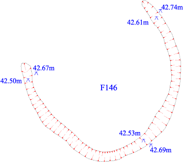
Post-excavation plan of ring ditch


